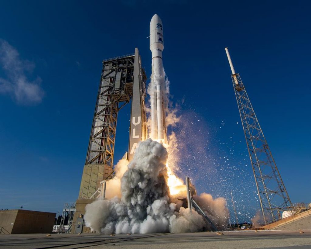
An Atlas V 541 rocket, from the United Launch Alliance (ULA) company, was launched into space this Tuesday from Cape Canaveral, Florida, with a high-definition environmental satellite, GOES-T, which will accurately measure the risk of natural disasters in the western US, Mexico, Central America, and the Pacific.
As explained on its website by ULA, a provider of spacecraft launch services for NASA, the rocket is coupled with the GOES-T spacecraft of the National Oceanic and Atmospheric Administration (NOAA), which will travel to “a geosynchronous transfer orbit optimized”.
It is the third satellite in the GOES-R series, which will provide NASA and NOAA with “continuous imaging and atmospheric measurements of the Earth’s western hemisphere.”
Using a state-of-the-art camera, the satellite will measure hurricanes, electrical storms, and tornadoes, among other natural threats, with greater precision and anticipation.
Liftoff went smoothly as planned at 4:38 p.m. local time from Space Launch Complex-41 at the Kennedy Space Center in Cape Canaveral.
WEATHER SENTINEL
The launch of the satellite is a coordinated effort between NASA, in charge of putting it into a geostationary orbit, 22,300 miles (about 35,900 kilometers) from the surface of the Earth, and NOAA, which will be responsible for its management once it is operative.
NASA detailed that this satellite will be placed in a geosynchronous transfer orbit, separated from the launch vehicle, and then moved to a higher geostationary orbit and renamed GOES-18.
“The end of my job is the beginning of in-orbit verification and operations that will continue for years and years. Once we separate the spacecraft into its correct orbit, we are done,” said NASA expert Rex Engelhardt, who is responsible for the GOES-T mission, according to a blog from the aerospace agency.
Once in orbit, the satellite will replace GOES-17 in monitoring the West Coast of the United States, Alaska, Hawaii, and the Pacific Ocean, including Mexico and Central America.
Among the specific benefits of this sophisticated system, NOAA highlights better-proven hurricane track and intensity forecasts and increased lead time for thunderstorms and tornadoes.
Similarly, there will be an earlier warning of hazards from lightning strikes to the ground, better detection of torrential rain, and flash flood risks.
According to NOAA, this technology will allow improvements in smoke and dust control, air quality warnings and alerts, and in fire detection and intensity estimation.
Other advances will be in the fields of low cloud/fog detection and transportation safety and aviation route planning.
It will also make more accurate warnings for communications and navigation outages and blackouts, and monitoring of energetic particles responsible for radiation risks.
The GOES-T (Geostationary Operational Environmental Satellite-T) design decreases the chance of future cooling system failure due to debris buildup.
In this way, it overcomes the problems that occurred with other satellites in the series and that caused “a partial loss of infrared images at certain times.”
The GOES-T also carries an enhanced magnetometer instrument for superior performance in measuring magnetic field variations.
These satellites also house instruments that detect and monitor space weather hazards, such as solar flares, and also contribute to early warning of outages in power utilities and communication and navigation systems, as well as radiation damage to spacecraft. orbiting satellites.
THE ULTRA-FAST CAMERA OF THE GOES-T
Built by the Lockheed Martin company, the satellite’s main instrument are its Advanced Baseline Imager, a camera for tracking weather, oceans, and the environment that can scan the Earth five times faster and with four times the resolution of its predecessors. , according to NOAA specialists.
The joint program between NASA and NOAA launched GOES-16 in 2016, followed by GOES-17 in 2018.
A fourth satellite will be put into orbit in 2024, details the specialized website Space.com.
“The GOES series has revolutionized severe event monitoring for us regarding storms and other environmental hazards, like wildfires, that is always a threat to our western states,” NOAA’s Steve Volz said recently.
